Historic Bridges in Kentucky: A Traveler's Guide
- Which historic bridges in Kentucky should you visit?
- What kind of bridge are you looking at?
- Which regions make useful starting points?
- Why start with Switzer near Frankfort?
- Can you add the Singing Bridge in downtown Frankfort?
- What makes the Big Four a different experience?
- Why include the Roebling in a Northern Kentucky trip?
- How should you visit High Bridge near Wilmore?
- What should you confirm before setting off?
- Sources
Which historic bridges in Kentucky should you visit?
Start with Switzer Covered Bridge near Frankfort for timber craftsmanship, the Big Four Bridge in Louisville for a pedestrian-and-bicycle river crossing, and the Roebling Suspension Bridge in Covington for suspension-bridge history. View the active High Bridge railway from High Bridge Park near Wilmore, never from the tracks. Confirm access before traveling: historic status does not grant entry, and Frankfort's Singing Bridge is currently closed to the public.
These are different kinds of outings, not interchangeable stops on a single driving loop. A creek-side covered bridge rewards attention to the structure; a city crossing offers a walk between neighborhoods; a railway bridge can be appreciated without setting foot on it. Choose the experience first, then build the route.
This is a selective Kentucky overview, not a complete inventory or live access service. The regional groupings below are our planning suggestions. Official source pages were checked on September 7, 2026; signs, closures and directions from the responsible authority take precedence.
What kind of bridge are you looking at?
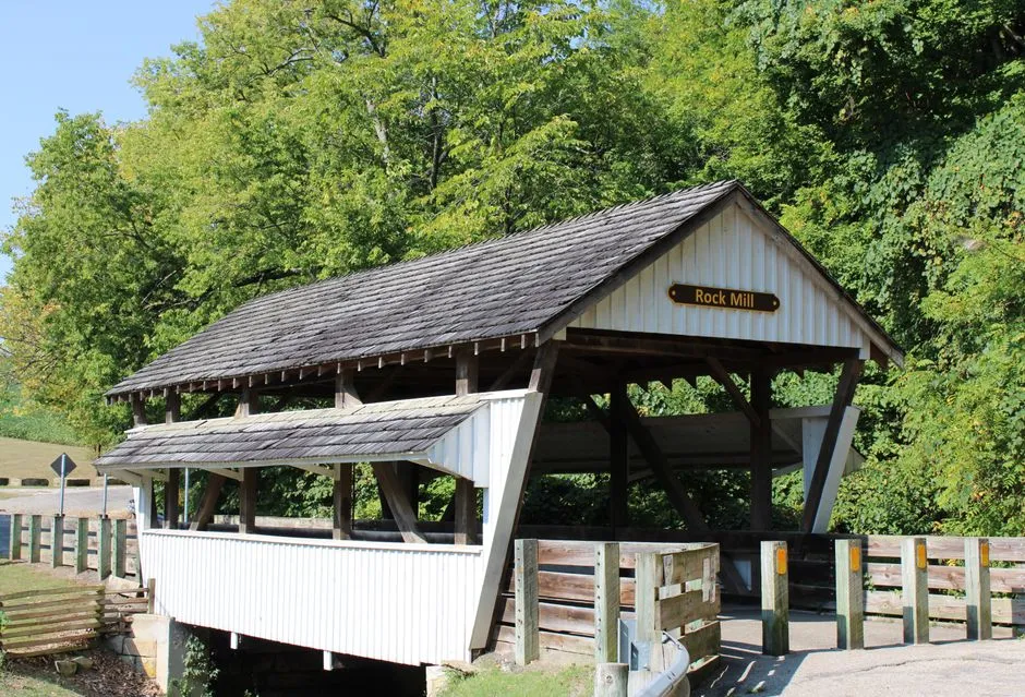
A covered bridge is more than a road with a roof. Its timber framework carries the crossing, while the roof and siding protect that framework from weather. The Federal Highway Administration's archived Covered Bridge Manual explains that protection of the structural timbers is the main reason for the covering. The portal, or entrance opening, may be the most recognizable feature, but the supporting framework is the part to understand.
A truss is a framework of connected members, including diagonals, rather than one solid beam. Timber trusses can be enclosed by a covered bridge; iron and steel trusses can be exposed. Names such as Howe and Pratt describe arrangements of those members, not paint colors or destinations. The FHWA's truss guide shows why two bridges with similar outlines may have different structural patterns.
Stone arches are another visual category: look for a curved opening formed by masonry. Do not confuse masonry towers or stone supports beneath a metal bridge with a stone-arch span. A natural rock arch belongs to geology, not the history of a constructed highway crossing.
Suspension bridges are recognizable by their towers, main cables and suspended deck. The Roebling provides a useful contrast to the timber work at Switzer and the exposed metalwork of the Big Four. You do not need to identify every component to enjoy the comparison. From a permitted viewing position, look first at what crosses the gap, then at what supports it.
An old appearance is not proof of age or condition. Restored bridges may combine historic design with replacement materials. The Kentucky Transportation Cabinet's cultural-resources program notes that metal truss bridges are becoming rarer on Kentucky roads and describes evaluation and relocation work. Preservation can involve change; it does not automatically mean public access.
Which regions make useful starting points?
| Base area | Principal example | Type of visit to plan | Important access distinction |
|---|---|---|---|
| Frankfort area | Switzer Covered Bridge | Covered-bridge visit | Closed to vehicles; confirm permitted pedestrian access |
| Downtown Frankfort | Singing Bridge | Historical context, not a crossing | Currently closed to the public |
| Louisville | Big Four Bridge | Pedestrian-and-bicycle crossing | Check park closures and bridge-specific rules |
| Covington | Roebling Suspension Bridge | Walkway or permitted riverfront view | Use only an open designated walkway, never the roadway |
| Wilmore/Jessamine County | High Bridge | Public-park viewing | Active railway; do not enter tracks or bridge |
For a first trip, our recommendation is one main bridge experience per day, with a town or park visit alongside it. This is a planning preference, not a claim that every stop requires a full day. It gives you room to read the interpretation, manage the approach and return, and change plans if access is restricted.
Do not connect these rows merely because they appear together in a guide. Check actual road distances from your accommodation. In particular, distinguish your driving destination from your walking starting point: a map pin on a bridge deck is not necessarily the visitor entrance.
Why start with Switzer near Frankfort?
Switzer offers a specific way to study a covered bridge without making an entire statewide collection the goal. Visit Frankfort's official listing places it off KY 1262 over North Elkhorn Creek. It identifies a Howe truss, saw-tooth entrance edges, a length of 120 feet and a width of 11 feet. The listing attributes the original construction to George Hockersmith around 1855 and records rebuilding in 1998.
Those two dates matter. A photograph of today's bridge should not be captioned as though every visible piece has stood unchanged since the nineteenth century. Look at the whole outline, the entrance detail and whatever structural members can be seen from areas open to visitors. The relationship between original design and later preservation is part of the story.
The official listing states that the bridge is closed to vehicular traffic. Do not navigate a car through it. Confirm pedestrian access, visitor parking and current opening arrangements with Visit Frankfort before departure; enter only where access is permitted.
For a longer timber-bridge itinerary, use our Kentucky covered bridge road-trip guide. Keep each additional stop conditional on its own access check rather than assuming all covered bridges operate alike.
Can you add the Singing Bridge in downtown Frankfort?
Not as a crossing. KYTC's Singing Bridge replacement project page, last updated July 27, 2026, states that the structure is closed to the public because of significant structural deterioration. It describes preliminary design for a replacement at the Bridge Street crossing of the Kentucky River.
This is a useful example of why an attractive bridge in an older travel guide may no longer be an accessible attraction. Do not enter the bridge, pass barriers or use a closed approach for photographs. If you want to see it from elsewhere, first confirm which nearby public spaces remain open and stay outside the closure area.
The project's intended future pedestrian access is not permission to walk there now. Check the project page again before a Frankfort visit; do not assume that a proposed construction schedule is a reopening date.
What makes the Big Four a different experience?
At the Big Four, the bridge is also a connection between Louisville's Waterfront Park and Jeffersonville, Indiana. Waterfront Park's bridge page dates its original railroad construction to 1895 and its rail decommissioning to 1969. The present walking-and-cycling use gives this former transport structure a different public role.
Choose it when your priority is being on a river crossing rather than seeing a rural covered bridge. Plan the approaches and the return as part of the outing; the central span is not the whole walk. Our Big Four Bridge walking guide explains the route-planning questions in more detail.
Check the park's current FAQ before leaving. It identifies possible icy-weather closures and closure during the Thunder Over Louisville air show, with other notices on official channels. A usual opening arrangement is not a guarantee for a particular visit.
Bridge rules also differ from rules elsewhere in the park. Pets are prohibited; service animals are permitted. Motorized vehicles, including electric scooters, are prohibited, while personal mobility scooters and motorized wheelchairs are allowed under the published rules. Check the exact device you intend to use and follow posted directions. Pedestrians and cyclists should leave room for one another.
Why include the Roebling in a Northern Kentucky trip?
The John A. Roebling Suspension Bridge links Covington and Cincinnati. The Roebling Bridge Society's history records its formal opening on January 1, 1867, following a pedestrian opening in December 1866. It also documents later reconstruction, including additional steel cables and a new steel truss and floor-beam system during work completed in 1899.
That history makes it more interesting than a single construction date suggests. It is a bridge that was adapted as transport demands changed. From an authorized viewpoint, compare the broad curve of the cables with the towers and deck below. The silhouette is the main contrast with a covered timber span.
Visit Cincy's walking guide describes a pedestrian connection between Smale Riverfront Park and Covington's Roebling Point. That establishes the kind of route, not its availability on your travel date. Check current KYTC and city notices for walkway or approach restrictions before committing to a crossing.
This is not a pedestrian-only bridge. Use an open designated walkway and the signed pedestrian approach. Never step into the vehicle roadway for a photograph, and do not treat a vehicle closure as permission to walk there. If the permitted route is closed, choose a confirmed open public riverfront viewpoint instead.
How should you visit High Bridge near Wilmore?
High Bridge belongs on a railway-and-landscape day, not a walking-crossings checklist. The Jessamine County joint tourism commission describes the bridge as still heavily used by trains and lists High Bridge Park at KY 29 and Old Park Road near Wilmore. The public park includes an overlook, a pavilion and picnic facilities.
Plan to see the railway from the park's permitted viewing areas. Do not enter the railway, walk onto the bridge or use trackside ground as a shortcut. Follow barriers at the overlook and supervise children around edges. An absence of trains at the moment you arrive does not make the railway accessible.
Ask about the park's current opening and the route from parking to the overlook if anyone in your party needs step-free access or a short walking distance. A public park listing alone does not establish the gradient, surface or accessibility of every viewpoint.
What should you confirm before setting off?
Separate three questions: is the structure present, is the destination open, and is your intended activity permitted? A historic listing answers the first imperfectly and may answer neither of the others.
Use the responsible park, city or county source for visitor access. For road conditions, KYTC directs travelers to GoKY in its travel-update guidance. Check pedestrian restrictions separately; a road traffic map is not permission to enter a footpath or bridge.
Before driving, identify lawful parking and the permitted approach. At rural stops, do not block driveways, stop in a traffic lane, enter private land or descend a creek bank to reproduce a photograph. If no safe lawful stopping place is available, omit the stop.
For any bridge still carrying vehicles, obey posted weight, width and height restrictions; do not estimate a vehicle's fit by looking at the opening. At every destination, respect closures and do not climb structural members or barriers.
Finally, save the official access page alongside the map. A satisfying bridge trip can be one structure understood well: why it was built, what carries it, how it has changed and how visitors can appreciate it responsibly today.
Sources
- FHWA: covered-bridge form and terminology and truss types.
- KYTC: cultural resources and historic bridges.
- Visit Frankfort: Switzer Covered Bridge.
- KYTC: Singing Bridge replacement and closure.
- Waterfront Park: Big Four Bridge and visitor FAQ.
- Roebling Bridge Society: bridge history.
- Visit Cincy: riverfront walking connections.
- Visit Jessamine: High Bridge Park.
- KYTC: travel-update channels.